 A Short Guide to Lo
While I don't profess to be the world's greatest
cartographer, the plan below should help you find some of the many good things
this delightful town has to offer.
Print out this page and take it with you when you are holidaying in West
Flanders.

1 -
Markey Molen (windmill)
2 - Westpoort – medieval gateway
3 - Cemetery
4 - Town Hall
5 - De OUDE ABDIJ Hotel
6 -
Duiventoren (dove tower)
7 - St. Pieterskerk (former abbey church)
8 - Supermarket
9 - Post Office
10 -
Stadhuis Hotel/Restaurant
11 -
De Vate (bar, snacks, lunches)
12 - Meat & cheese shop
13 - Bakery & cakeshop
14 -
Lauka
– Tourist Office
15 - Fruit, cheese, beer shop
16 -
Bakery & cakeshop
17 - Destrooper biscuit shop
18 - Klooster (convent)
19 - Pond
20 - KCB Bank
An alternative view says that the settlement itself appears to have grown up round a fortified residence built by Filips van Lo (who died in 1104). He, and later his illegitimate son Willem van Lo, lived in the fortress which was near Rozestraat, though nothing remains to be seen. Willem made many grants of land to the canons attached to his chapel and these monks gradually acquired an estate of around 500 hectares. Willem, also known as Willem van Ieper, could afford to be philanthropic - he had a successful career in England as a mercenary, becoming a significant figure and the right-hand man of King Stephen, with a reputation for cruelty and efficiency. In his old age he was forced to leave England and in 1154 he withdrew to his residence in Lo, where he died in 1164. In 1770 his remains were dug up and reburied in the south choir of St Pieter's, the parish church whose tower casts a shadow over the site of his old castle.
In 1167 Count Filips van den Elzas (Alsace) granted town status to Lo, and, in order to protect the town during the conflicts between the Flemish and the French, it was surrounded by a moat and an earth bank pierced by four gates was built in 1214. You can still see the west gate (number 2 on the map), and you can get more information about the fortifications of medieval Lo at www.fortifications.org where you will also find a suggested town walk.
During the Middle Ages Lo became known for textiles. Around 1540 the textile trade was dying out and was replaced by cheese making. (We suggest you go into one of the shops or restaurants to try the excellent local cheese - you'll be getting a taste of history!) The town suffered in the wars of religion in 1578, with the protestant armies destroying many of the monastic buildings in Lo, and the abbey church was completely destroyed by fire in 1580. The buildings were reconstructed starting in 1608 and the second phase of the work was completed in 1782, only to suffer again in 1797 during the French Revolution, when the monks were driven out and monastic buildings either demolished or turned to secular use.
The town suffered badly again in the First World War, but recovered, so that in 1985 it officially received town status. Today it is a picturesque and peaceful place, easy to reach from the Southern England, which makes an excellent base for touring West Flanders and investigating Belgian beers. In the 19th century Lo had about 1500 inhabitants - and four breweries! Although there is no active brewery in the town today it is still possible to trace Lo's brewing heritage - see the sections titled in red.

1 - As you enter Lo from the west you cross the bridge (Lo Brug) over the canal (Lovaart) and you will see a restored windmill on your left. This is the Markey Molen, named after a former miller. Built in 1797, it was restored in 1991-2.

The canal was built in the 12th century to link Lo and Veurne with the harbour of Nieuwpoort. On the town side of the canal roads run north to Alveringem and south to Fintele, and can be a pleasant country walk or drive.
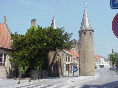 2
-In medieval times the town was
much smaller, only about 400m in diameter, and
surrounded by an earth bank and a moat. There were four gateways, but only
the Westpoort (West gate) survives, having been restored in 1852 and again
in 1991. As you drive in to the town from the west you pass to the
right of this gate and your teeth start to rattle as the car moves on to the
cobbled surface.
2
-In medieval times the town was
much smaller, only about 400m in diameter, and
surrounded by an earth bank and a moat. There were four gateways, but only
the Westpoort (West gate) survives, having been restored in 1852 and again
in 1991. As you drive in to the town from the west you pass to the
right of this gate and your teeth start to rattle as the car moves on to the
cobbled surface.
Left of the gate you can see Caesarsboom (Caesar's tree), supposedly where
he hitched his horse while on his way to sort out the Brits!
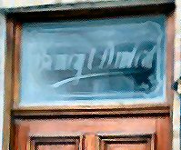 Damberd
Brewery -
The house next to the famous
Caesar's tree is called Het Damberd and is described in
records from 1499, as being the site of a brewery - the oldest of the four
breweries which used to exist in Lo. Parts of the present building
date from the 17th century and 'Brouwerij Damberd' is etched in the glass
above the front door. It belonged to the Croigny-Decroix family and
was known as the Damberd brewery, although from 1905 to 1914 it was listed
as Croigny-Van Eecke. ( It will be interesting to see if further research
produces any links to the present-day Van Eecke brewery in Watou.)
From 1915 to 1932, when it closed, it was run by Emile Croigny. So far
we have not come across any record of the beers they produced.
Damberd
Brewery -
The house next to the famous
Caesar's tree is called Het Damberd and is described in
records from 1499, as being the site of a brewery - the oldest of the four
breweries which used to exist in Lo. Parts of the present building
date from the 17th century and 'Brouwerij Damberd' is etched in the glass
above the front door. It belonged to the Croigny-Decroix family and
was known as the Damberd brewery, although from 1905 to 1914 it was listed
as Croigny-Van Eecke. ( It will be interesting to see if further research
produces any links to the present-day Van Eecke brewery in Watou.)
From 1915 to 1932, when it closed, it was run by Emile Croigny. So far
we have not come across any record of the beers they produced.St. Joseph Brewery - Just the other side of the Westpoort, at Weststraat 2, is a house which belonged to the Rouzée family. They owned the St. Joseph brewery, which was probably nearby. The brewery closed in 1955 and is recorded as producing the following beers: 3 Klas Bier, Blond, Gerstebier, Gersthop, Gersthop Tripel, Guld'n, Kl. (2) II, Kriek, Primablond, Speciaal, and Stout.

3 -If you are heading for the Oude Abdij Hotel, having passed the Westpoort you turn left into Oude Eier Markt (Old Egg Market), where you see this small cemetery in the shadow of the parish church.

4 – You turn immediately right after the cemetery and find yourself
in front of the Town Hall, where the word ‘Loo’ is embedded in the roadway.
(To avoid any misunderstanding by English speaking visitors
we should point out that this is the old spelling of the town’s name!)
This building is said to be the guest house of the former abbey, and the
presbytery, on the north side of the cemetery, contains parts of the abbot's
residence.

5 - Just beyond the Town Hall you find the drive leading to De Oude Abdij Hotel. As well as being our favourite Belgian hide-away it has the distinction of having been part of the original St Pieters abbey and later in its history housed the St Louis Brewery, owned by the Verlende family. You'll find more details about the present-day hotel here and the story of the St Louis Brewery is recounted in the Secret History of De Oude Abdij.

6 - Perhaps one of the most famous landmarks of Lo, the Duiventoren or dove tower (to translate its name as 'dovecote' would greatly understate its size!) can be found in the gardens of De Oude Abdij. Built into a wall which formed the boundary of the former abbey it contains nesting boxes for some 1132 doves. It was built by the monks in 1710 as a present for the abbot. In those days such buildings were not only a status symbol but an important source of food. If you want to go inside, you need to go through the gateway in the car park to get into the lane beyond the wall. The tower now contains an information centre about the former abbey.
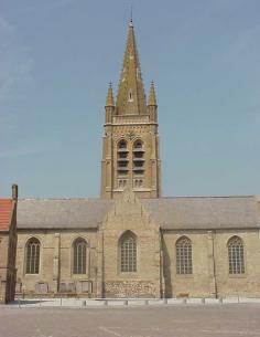 7
- St Pieterskerk is the parish
church of Lo, seen here from the market square. A church was recorded
on this spot in 1119 and was part of the Augustinian abbey which occupied
the northern part of the town (called Noordover) from 1093 to 1797.
Part of the church was used by the monks and part served as the parish
church.
7
- St Pieterskerk is the parish
church of Lo, seen here from the market square. A church was recorded
on this spot in 1119 and was part of the Augustinian abbey which occupied
the northern part of the town (called Noordover) from 1093 to 1797.
Part of the church was used by the monks and part served as the parish
church.
The monks were driven out during the French Revolution and when the parishes
were subsequently restored the whole building was used as the parish church.
The church was all but destroyed in the First World War but the church
furnishings had been put into storage and were replaced when the church was
rebuilt between 1919-1924.
The church is open on Thursday mornings throughout the year, and daily from
2.30pm to 5.00pm in July and August.
A path leads from the Oude Abdij driveway (above) to the gardens behind the
church and emerges at the right hand side of the church, forming a pleasant
short cut from the hotel to the square.

10 - Stadhuis This building, in the cobbled
market square across the road from the church, was the town hall of Lo but
is now a hotel and restaurant. It was built in 1565-66 by
Joos Staesin of Ieper to replace a former building which had fallen into
disrepair. The tower housed the town clock and a carillon, although
today it is only the church clock which you will hear striking the hours.
The unusual projection flanked by two pillars and covered by an arch forms
the area called the 'pretecke' from which official announcements were read.
Shopping in Lo
8 - Supermarket Going east along Oostraat you'll find a small
supermarket on the left which manages to pack a lot into a small space.
They often have presentation packs of beers & glasses, as well as selling
the local cheeses etc.
9 - Lo Post Office across the square from the Stadhuis, is flanked by
a very good optician and a gift shop.
12 - Meat & cheese and 13 - Bakery & cakeshop are next to De
Vate (11) - behind the horses in the photograph. Useful for a
take-away snack or treat, also worth window-shopping to see the attractive
things on offer - the Belgians appreciate good food!
15 - Fruit cheese beer This little shop on the north side of the main
street opposite the square is definitely worth a look, especially if you
want some local gifts to take home. Local 'Lauka' beer, wines and
liqueurs in fancy bottles, unusual beers (like St Sebastiaan in stone jars
or Rader beer made with jenever), as well as a fine selection of local
cheeses, fruit, rolls and everything for a picnic lunch.
16 - Bakery & cakeshop Close to the Westpoort, this is another place
to find excellent bread and cakes to help you forget your diet.
17 - Destrooper biscuit shop Jules Destrooper, whose factory is based
in Lo just behind the Klooster (18), makes the best-known Belgian
biscuits. You're sure to find the standard boxes in your local Sainsbury,
Tesco etc. However, if you come to their factory outlet you'll find a
wider range of styles and flavours, a superb variety of gift boxes, and if
you explain it's for a present, the staff will wrap your purchases like a
work of art for no extra charge. But if you're there because you want
some biscuits as a treat for yourself, ask what 'seconds' they have on
offer. These boxes, marked with a blue cross, are where the biscuits
aren't quite the right shape, or the chocolate decoration is wobbly - but
they cost considerably less and taste just as good!
20 - KCB Bank is close to the corner of Oude Eier Markt, where you
turn towards De Oude Abdij Hotel. Useful if you need to change some
more sterling into Euros but check the opening times.
11-
De Vate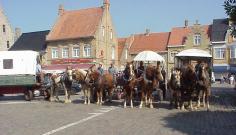 If you want a drink, tea or coffee, snack or more substantial lunch, this is
our favourite spot.
If you want a drink, tea or coffee, snack or more substantial lunch, this is
our favourite spot.
It is the tall, red-roofed building in the photograph and stands in the
square at Markt 3, a couple of doors down from the Stadhuis.
As well as Boterhammen (open sandwiches) they do a 'Loose Schotel' (Lo
Plate) featuring meat and cheese specialities of the area and also offer a
tempting range of pancakes. For a lighter lunch go for a bowl of home made
soup - 'verse soep'
If you're here in the winter months try their 'Warme wijn' - mulled wine -
or if you prefer a beer go for the '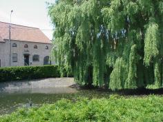 Tongerlo
Christmas' seasonal brew.
Tongerlo
Christmas' seasonal brew.
De
Vate is closed on Tuesdays, and you're only likely to see the horse-drawn
carts if you're here in the summer, or make special arrangements through the
tourist office (14)
De Vate takes its name from the Vatevijver,
the town pond (19), which is just opposite. This ancient pond, first
recorded in 1404, was used to store fish but also served as a water supply
in case of fire. Today it provides a haven for a family of swans.

18 - Klooster (convent) The building to the left
of the Tourist Office, behind the green, is the Convent of the Grauwe
Zusters (Grey Sisters or Poor Clares) of Nieuwpoort, and dates from 1497,
but was enlarged in 1654-55. The nuns first came to Lo in 1492 to take
care of plague victims and poor persons who were ill. The convent is
not open to visitors.
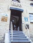 14 -
Lauka Tourist Office can be found in the building
just behind the pond (above), which once housed the
Pillaert Brewery.
Owned
by the Pillaert-LaHaye family, it is known to have operated between
1915 and 1932 when it closed, but we have no record of the beers produced
there.
14 -
Lauka Tourist Office can be found in the building
just behind the pond (above), which once housed the
Pillaert Brewery.
Owned
by the Pillaert-LaHaye family, it is known to have operated between
1915 and 1932 when it closed, but we have no record of the beers produced
there. The tourist office can provide lots of local information leaflets and maps, and is open 9.30-12.00 and 13.00-17.00 (16.00 Fridays), closed Sundays (except July-August). In the basement you'll find 'Retro Destrooper' and exhibition showing the history of the famous biscuit factory (see 17 for their products).
Lauka's own website is at www.lauka.be - it's in Flemish, but just click all the links and you'll see lots of illustrations.